
+- Punaweb Forum (https://punaweb.org/forum)
+-- Forum: Punaweb Forums (https://punaweb.org/forum/forumdisplay.php?fid=3)
+--- Forum: Punatalk (https://punaweb.org/forum/forumdisplay.php?fid=10)
+--- Thread: Kilauea Eruption 12/23/24 (/showthread.php?tid=23505)
RE: Kilauea Eruption 12/23/24 - leilanidude - 10-05-2026
Several businesses in Volcano display the YouTube channel below on tv for their customers.
---------
Luquin's has been doing that for over a year.
RE: Kilauea Eruption 12/23/24 - HereOnThePrimalEdge - 10-08-2026
Magma is on the move. Detailed info at the link.
The patterns of surface deformation show that the dike extends from the established vent area in Halemaʻumaʻu and cuts across the northwestern part of Kaluapele. The deforming areas following parallel to the western rim of Halemaʻumaʻu and Kaluapele are very narrow and elongate, mapping the path of magma intruding within a thousand feet (about 300 meters) or less of the surface. The path of the dike follows fractures in the caldera floor that formed in 2018 and created a series of new, small fractures that were identified on other satellite images.
https://volcanoes.usgs.gov/hans-public/notice/DOI-USGS-HVO-2026-10-08T01%3A00%3A28%2B00%3A00
RE: Kilauea Eruption 12/23/24 - MyManao - 10-08-2026
(10-08-2026, 03:18 AM)HereOnThePrimalEdge Wrote: Magma is on the move. Detailed info at the link..
As they say a pic is worth way more than a handful of words.. and even though HVO writes 'em pretty.. from a volcanophine's perspective... by comparison an Interferometric Synthetic Aperture Radar (InSAR) satellite image is a very spicy kine dream come true.. and this one don't disappoint..
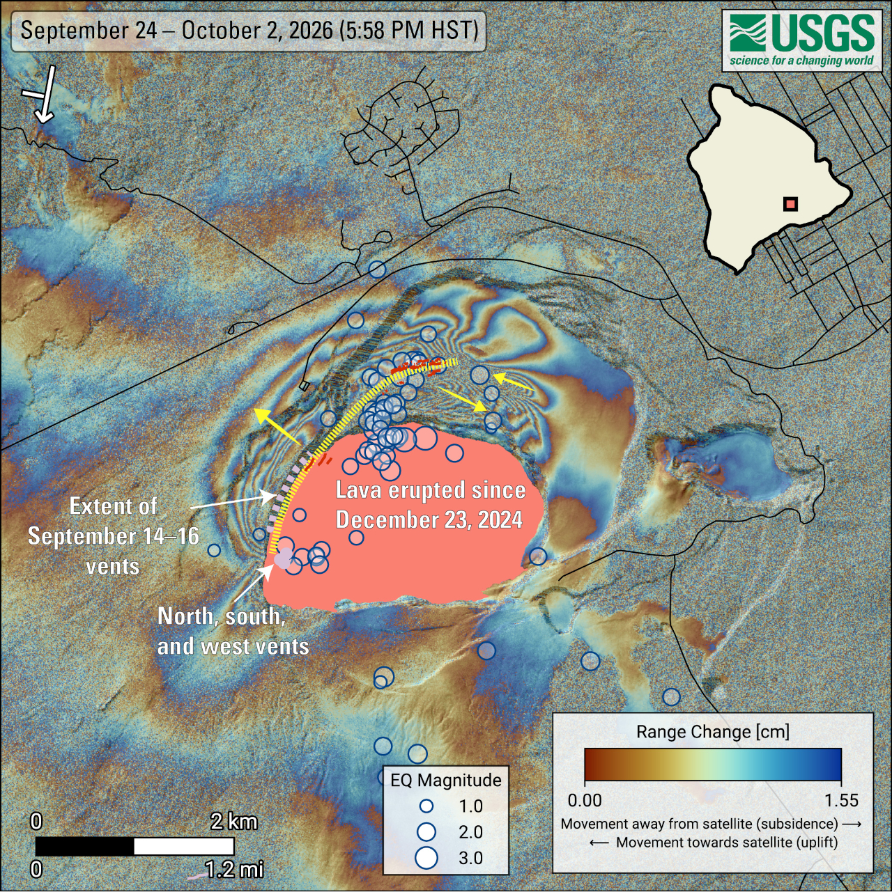
And HVO's Caption..
USGS: “COSMO-SkyMed Second Generation (CSG) interferogram showing deformation of the ground surface around the summit of Kīlauea volcano from September 24 to October 2, 2026. Blue circles mark earthquakes recorded during this period, with larger circles representing stronger earthquakes. Most of the earthquakes occurred between September 30 and October 1, 2026.The yellow dotted line and arrows show the main path of the underground intrusion and the relative motion of the ground surface, respectively. New cracks, which likely opened around September 30, were identified through various remote-sensing methods, and are shown in red. The pattern of deformation is consistent with a shallow, nearly vertical sheet of magma—called a dike—located about 1 kilometer (~0.6 miles) or less beneath the yellow line.The symbol in the upper-left corner shows the satellite’s flight direction with an arrow and its viewing direction with a bar. The pink polygon represents the lava flows covering the crater floor. Main vents are shown as light-purple circles, while the extent of vents and fissures that opened between September 14 and 16, 2026, is shown as a light-purple dashed-line. Roads are shown in black. The satellite data used to generate the interferogram were provided by the Italian Space Agency (ASI, Agenzia Spaziale Italiana).”
Reproduced from BIVN.
RE: Kilauea Eruption 12/23/24 - Durian Fiend - 10-09-2026
The yellow dotted (?) line. No wonder the Halema'uma'u trail and part of Byron ledge is closed.
RE: Kilauea Eruption 12/23/24 - HereOnThePrimalEdge - 10-17-2026
Saturday morning:
The fountain is on. Beautiful nighttime video if you scroll back
https://www.youtube.com/live/gXKuUyKt8mc?si=kRW0iNJ-AsZGQ7eo
RE: Kilauea Eruption 12/23/24 - Obie - 10-17-2026
That didn't last long.