Posts: 2,168
Threads: 25
Joined: Oct 2016
From Hilo TH:
Hilo international airport, with 3.75 inches of rain, and Waiakea Experimental station, with 4.7 inches, had their driest July since 2010..."
This on top of several previous dry months puts Hilo at 34.3 inches of rain for the year.
Posts: 11,242
Threads: 358
Joined: Apr 2009
I haven't been able to keep track of the current hurricane season this summer, nor the conditions in the East or Central Pacific. However, I did briefly look at the NOAA website and see that Kiko has formed in the Eastern Pacific and will likely become a hurricane as it heads westwards and is predicted to remain a hurricane until the end of the current forecast period. Anyone with any more info?
Posts: 600
Threads: 32
Joined: Jun 2020
Tropical Storm Kiko formed overnight and is headed in our general direction:
https://www.nhc.noaa.gov/graphics_ep1.sh...t#contents
The discussion page at the above link has some conjecture on what may happen beyond the five day track forecast currently posted.
Posts: 2,168
Threads: 25
Joined: Oct 2016
(08-31-2025, 05:51 PM)ChunksterK Wrote: Tropical Storm Kiko formed overnight and is headed in our general direction:
https://www.nhc.noaa.gov/graphics_ep1.sh...t#contents
The discussion page at the above link has some conjecture on what may happen beyond the five day track forecast currently posted.
I don't see any discussion about possibilities beyond 5 days.
It's tracking well south of us so far and is expected to continue this for a while. Considering how dry our island has been, it'd sure be nice to get some moisture from this storm-but no wind!
Posts: 11,242
Threads: 358
Joined: Apr 2009
08-31-2025, 08:27 PM
(This post was last modified: 08-31-2025, 08:30 PM by TomK.)
Chunkster - I'm not sure if you were responding to my post or if we just happened to post at the same time. It's late where I am, but I was wondering if anyone has information about forecasts beyond the NOAA guidance, particularly ocean temperatures and shear as Kiko nears Hawaii. The NOAA forecast suggests the storm is on a knife-edge, and any deviation to the "right" (I take that as a deviation to the north) would weaken the storm, but that's within the 5-day forecast. I see no discussion that discusses things beyond that period.
In any case, I think all I'm asking is how conducive the conditions closer to the islands are for hurricanes to remain a threat right now.
Posts: 1,120
Threads: 10
Joined: Aug 2016
The previous storms that have headed our way but on a more northerly track have dissipated before they got here due to the unfavorable conditions. The statement “any deviation to the right would weaken the storm” indicates to me that those unfavorable conditions still exist.
Posts: 12,617
Threads: 821
Joined: Sep 2012
Posts: 1,676
Threads: 36
Joined: Jun 2020
08-31-2025, 09:11 PM
(This post was last modified: 08-31-2025, 09:12 PM by MyManao.)
(08-31-2025, 08:38 PM)My 2 cents Wrote: The previous storms that have headed our way but on a more northerly track have dissipated before they got here due to the unfavorable conditions. The statement “any deviation to the right would weaken the storm” indicates to me that those unfavorable conditions still exist.
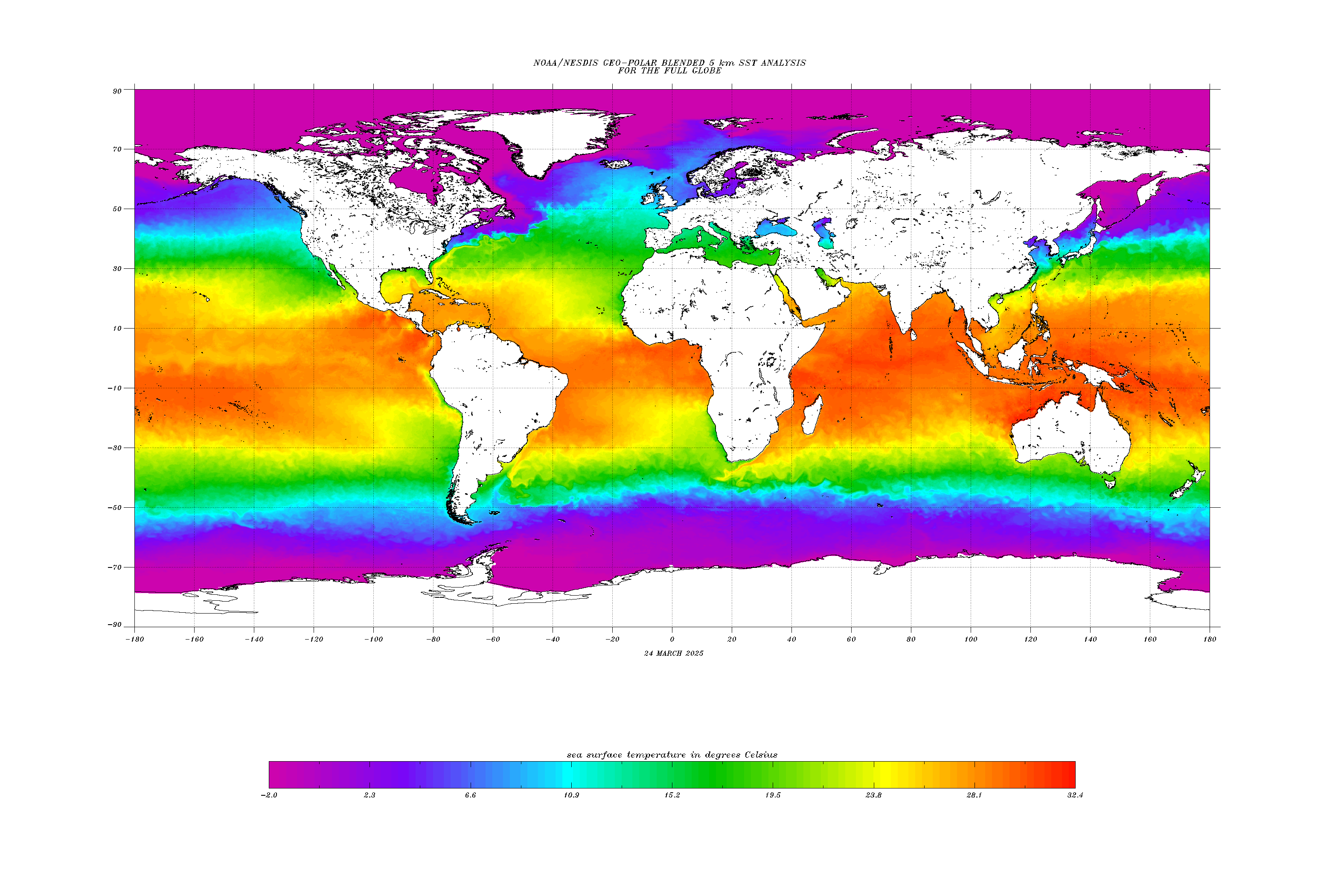
The energy for a storm of this nature is primarily derived from high ocean temps. With Kiko's current location and projected path, below the 15th parallel, it appearing to be hugging, following, the temperature gradient seen in NOAA's whole planet ocean temperature map below. And, with any luck, the storm would be appreciably weakened if it veers, as the statement mentions "to the right" which I assume is to the north into immediately cooler water.
The thing we have going for us, in this instance, is that wedge of cooler water (in greens) that is reaching, barely but still, towards our southern side from the east. Of course, if the storm turns towards us, and were to have enough momentum built up by the time it does, this is a fairly small barrier to be putting all our hopes on..
From.. https://www.ospo.noaa.gov/data/sst/conto...all.cf.gif
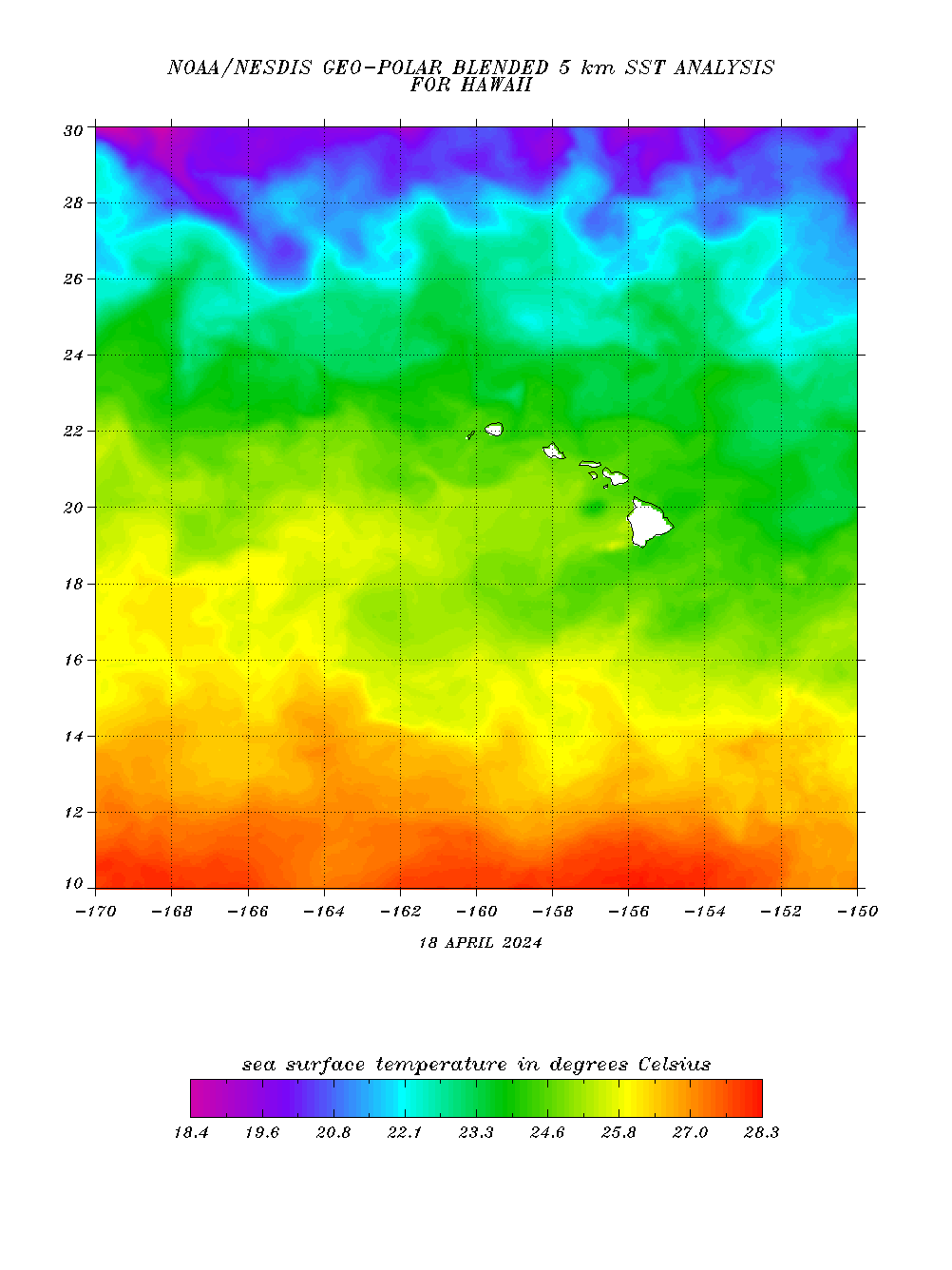
For a more nuanced view of temps around the islands here's NOAA's close up view of the area around the state..
From.. https://www.ospo.noaa.gov/data/sst/conto...aii.cf.gif
Posts: 600
Threads: 32
Joined: Jun 2020
Sorry HOTPE, I was wrong about the NOAA going beyond five days. The 11am update continues to note that if the storm takes a more northerly track, i.e. closer to Hawaii, the strength would be less due to cooler ocean surface temperatures. Farther south, it would be stronger storm, but presumably more likely to miss us. And of course all of this can change quickly. The latest discussion also points out that the two best regarded prediction models, the ECMWF and GFS have dramatically different projections of forward speed.
Tom: Although it's way to early to make any assumptions, there is a longer outlook on Windy: https://www.windy.com/?19.593,-155.006,5 . They show the European (ECMWF) model with Kiko over or near Kapoho with 35-40 mph winds around 8pm on Tuesday, September 9. On the other hand, the GFS on Windy shows it passing north of us around the same time with somewhat stronger winds. Now you've probably noticed that that does not match what the NOAA said in terms of speed. Either Windy has not updated in the past hour, or their software is misinterpreting one or both of the models. If you go to Windy right now, it might look very different yet again.
Those differences are a clear message about the uncertainty of these things this far out.
Posts: 2,168
Threads: 25
Joined: Oct 2016
(08-31-2025, 08:42 PM)HereOnThePrimalEdge Wrote: ECMWF:
https://weather.us/cyclone-tracks#:~:tex...20forecast.
This one and the GFS are currently suggesting the storm will track quite close to us.
|




