


(09-23-2026, 02:06 PM)Durian Fiend Wrote: On one side..
On the other side..
I vote for it leaving us alone.
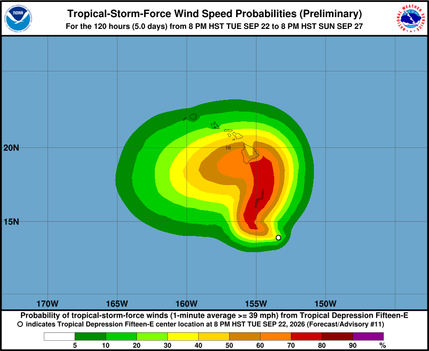
And then find this interesting graphic from BIVN which seems to suggest our Maunas play a role in the way the wind behaves around them..
|
Hurricane season 2026
|
 (09-23-2026, 02:06 PM)Durian Fiend Wrote: On one side.. I vote for it leaving us alone. And then find this interesting graphic from BIVN which seems to suggest our Maunas play a role in the way the wind behaves around them..

Unfortunately, Puna is on the less favorable side of the Maunas for this storm track, but yeah, I too vote for it to reconsider and head elsewhere - will even craft a homemade ballot and mail it, or drop it in: a dropbox, a newly forming backyard stream, or the CAT3 110+ mph winds now under consideration... (TropicalTidbits shows storm intensity models ranging all over the place from just a tropical storm to a strong Cat3 as the storm passes south of us. Will the storm get this bad? Hard to say, but clearly the answer is yes, no, or maybe. ;)
09-23-2026, 07:12 PM
09-23-2026, 10:26 PM
The National Hurricane Center doesn't mention the Maunas,
Nolo is moving west-northwestward at about 5 kt. There is no change to the synoptic reasoning with a ridge located to the northeast of Hawaii forecast to weaken and push eastward as a mid- latitude trough deepens over the northwestern Hawaiian islands. This pattern is likely to the cause Nolo to slow down tonight and then turn north-northeastward by tomorrow with some increase in forward speed. The trough is forecast to move westward this weekend as the ridge rebuilds north of Hawaii, which should force a sharp leftward turn while the cyclone is close to the Big Island. It really depends on how far northeast Nolo gets before the ridge rebuilds, with the solutions that gain the most latitude in the next few days generally getting closest to Hawaii. Although there has been a small southward shift in the overall guidance on this cycle, there is still a large spread approaching 250 n mi from north-to-south by the weekend. The new forecast is nudged south on this advisory, but it should be considered low confidence. 
09-24-2026, 05:14 PM
(This post was last modified: 09-24-2026, 05:16 PM by HereOnThePrimalEdge.)
Much less rain last night than predicted. I checked in with Harry:
Nolo has not made much northerly progress over the past day, so the north turn starts at a more southerly point and ends at a more southerly point supporting the scenario that damaging winds remain offshore, except at higher elevations and downwind of slopes. My weather app had said 4” of rain each day for the next 3 days, this morning that’s been adjusted down to 2” a day (for HPP). The wind estimates have also been reduced. ECMWF has one of the more favorable forecasts, showing the storm will turn west earlier and further south from Big Island, as well as staying a tropical storm, not developing into a Cat 2 or 3 hurricane as some models show. The turn to the west should occur about 7 AM Saturday morning (1700 UTC = 7 AM HST) sooner is better, later brings the storm closer to us. Higher rain totals and stronger winds up Hawaiian Acres, Volcano, Na’alehu, etc. but all in all a more favorable forecast this morning than yesterday. The storm is slow moving, so Thursday-Friday-Saturday will be wet and windy.
09-24-2026, 05:42 PM
The NHC doesn't agree with Harry and they are saying it will now travel closer to the Big Island before it makes it's turn.
09-24-2026, 05:50 PM
(This post was last modified: 09-24-2026, 08:01 PM by HereOnThePrimalEdge.)
The NHC doesn't agree with Harry
As with Lala the models are widely divergent at this point before closest approach. Best to consider all possible scenarios today and tomorrow. Late Friday or early Saturday should bring the models into closer alignment. Thanks for the NHC forecast Obie.
09-24-2026, 06:00 PM
The NHC doesn't agree with Harry
Googles mindfuck has the track closer to us.. whereas the good ol' tried and true ECMWF (seen on google's big shiny new toy as well as elsewhere) has it further to the south. Most of the modeling is favoring NHC/google's... so far. Harry is just clickbait.
Just to make the differences in the paths a bit clearer:
This may provide another useful comparison point between the Google and ECMWF models. World Wide Weather Watch is back on the beat as well, with some comparisons between various and unique models and how they've change day to day, along with possibly another pass by Kauai ultimately.
09-24-2026, 07:41 PM
(This post was last modified: 09-24-2026, 07:41 PM by Durian Fiend.)
(09-24-2026, 05:42 PM)Obie Wrote: The NHC doesn't agree with Harry and they are saying it will now travel closer to the Big Island before it makes it's turn. Yes, they do agree. Look at yesterday's NHC map contained in post 283 and compare it to today's map from them. |
|
« Next Oldest | Next Newest »
|