


09-24-2026, 07:46 PM
Despite the differences in forecasts, it appears that we should not experience hurricane force winds in Puna.
Fingers crossed on that one.
Fingers crossed on that one.
Certainty will be the death of us.
|
Hurricane season 2026
|

09-24-2026, 07:46 PM
Despite the differences in forecasts, it appears that we should not experience hurricane force winds in Puna.
Fingers crossed on that one.
Certainty will be the death of us.
 (09-24-2026, 06:17 PM)ironyak Wrote: Just to make the differences in the paths a bit clearer.. That's a whole lot of difference when in comes to impacts to the island.. somewhere between a breezy day and it huffed and buffed and blew the house down.. (09-24-2026, 07:46 PM)kalianna Wrote: Despite the differences in forecasts, it appears that we should not experience hurricane force winds in Puna. I think that's still open for debate. If you look at the width of the wind field on the NHC wind map..  and then move the white dot up to the 17.5N.. google and the NHC predicted.. (it's currently at 15N) and then take the width of the higher wind filed, say light brown and up, it's a toss up. That's why the ECMWF model is so preferable. Again.. I vote.. if we're still allowed to vote.. that da buggah goes elsewhere.
09-24-2026, 08:29 PM
(09-24-2026, 07:41 PM)Durian Fiend Wrote:(09-24-2026, 05:42 PM)Obie Wrote: The NHC doesn't agree with Harry and they are saying it will now travel closer to the Big Island before it makes it's turn. I'm on my cell and can't really copy and paste right now but I was referring to the forecast discussion that HOTPE posted from Harry and he said it turned north earlier,so it's going to turn west sooner and avoid the Big Island. The NHC in the 5:00 am forecast discussion is saying it has slowed down and hasn't turned yet and that will take it closer to South Point. They also mention the Mauna influence. 
09-24-2026, 08:43 PM
(This post was last modified: 09-24-2026, 08:43 PM by HereOnThePrimalEdge.)
appears that we should not experience hurricane force winds in Puna.
Fingers crossed on that one. I think that's still open for debate. MyManao, The forecast map you posted shows a 90% possibility of 39+ mph winds in the dark purple area. That’s still well below 75 mph hurricane wind speeds.
09-25-2026, 02:30 AM
(This post was last modified: 09-25-2026, 02:33 AM by HereOnThePrimalEdge.)
I can’t do an overlay, but if I’m reading the forecast correctly:
* models are converging, the left turn will occur earlier (Sat 3 AM) so will keep storm farther to the south * ECMWF is now showing a Cat 1 storm developing, but not for any length of time Every update has indicated less wind and less rain for us. Let’s hope this trend continues. (Thanks ironyak!)
09-25-2026, 02:53 AM
I hope you are reading the forecast correctly.
Certainty will be the death of us.
09-25-2026, 03:02 AM
(09-25-2026, 02:53 AM)kalianna Wrote: I hope you are reading the forecast correctly. Here's an interesting tidbit, that may be working in our favor, if less wind 'n rain is favored... Here are two captures of the NHC's plots.. 1.. from 11pm Wednesday.. 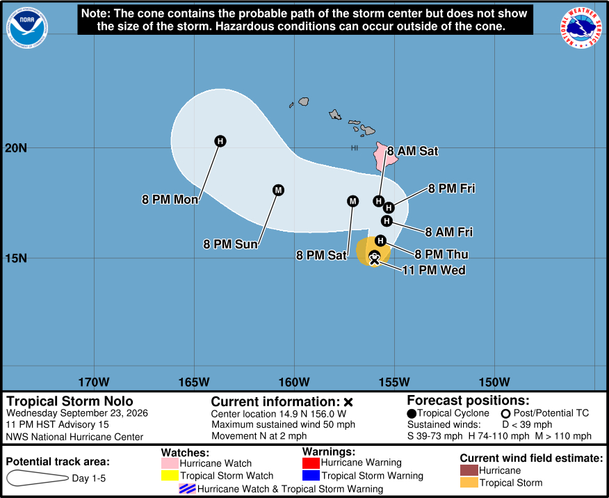 and 2.. from 11am Thursday.. 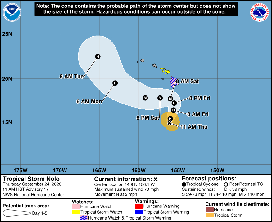 in which, when comparing the two, we see the storm hasn't moved. Their captions say the thing is crawling at 2mph.. stationary.. but the projected dots.. in the first one suggest the NHC expected the storm to move. So, maybe, this is to say the longer the storm lallygags around the further north it won't go becaue the ridge that is expected to form and deflect it to the west is still going to form.. and it'll form when the storm is further south than originally projected..
09-25-2026, 03:06 AM
A good summary of the situation from Durgin, 3 hours ago. I added the bolding:
"...Yesterday all the high resolution models, except for the HMON, turned Nolo west between 17N and 18N, far enough away to keep the strongest winds offshore. This afternoon the HMON joined the club and now also shows Nolo turning west around 18N. Models are in unison calling for the ridge to the north of Nolo to rebuild and push Nolo off to the west late Friday or early Saturday. The question will be how fast Nolo moves north between now and then. Nolo's damaging winds are about 240 miles away and the storm is forecast to begin turning west in about 24 hours, so the storm would need to pick up speed and head north at 10 mph. I'll be keeping an eye on that track speed, because we don't want any bad surprises. If everything happens as expected winds are strong and gusty with some power outages. The rain is still expected to be heavy with widespread flooding, especially Friday night into early Saturday..."
09-25-2026, 08:47 AM
Cool new (at least new to me) website. Shows rain totals and wind gusts and updates every five minutes.
https://www.hawaii.edu/climate-data-port...0TnPDQeojA
Certainty will be the death of us.
|
|
« Next Oldest | Next Newest »
|
