


TomK - So go ahead and describe them. You present two pictures, not models, so what units are on the axis, and what nuances are involved in these models?
lol, nah brah, do your own homework - the image has all the info you need if you care to learn more. You want to know about decibels of reflectivity (dBZ) read this, or MSLP (in millibars) you can try this. Want to know about the HAFS models - can read this, or play with them here, or read what Durgin said about the differences:
"The TLDR version is that the HAFS-A uses a static vortex initialization technique, inserting a synthetic storm vortex that is blended with the background field, while HAFS-B assimilates satellite and observational data more directly using a more advanced 4D-EnVar data assimilation system. This makes HAFS-B generally better at capturing observed structure and recent intensity trends, especially in well-sampled systems. However, HAFS-A can sometimes offer more stable long-range guidance because of its smoother initialization. The physics packages and dynamics are nearly identical, so differences in output—especially in intensity, structure (e.g., annularity), and track sensitivity—often reflect these initialization differences."
Is he right? Hell if I know, and it doesn't really matter to me as someone not trying to pretend to know the future - I understand that we're all just playing with various techno-crystal balls that are all wrong at different times in one way or another.
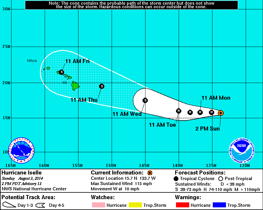
As a "fun" reminder of the fallibility of predictive models, here is the NWS 5-day forecast for Iselle in 2014, which also shows the storm center passing to the north of us. Is that how it went, or did we get to spend days chainsawing out blocked roads and weeks without power after the storm hit lower Puna? (ETA:Those winds from the counter-clockwise rotation and path to the south were no bueno here or for Lahaina in 2023, diba?)
lol, nah brah, do your own homework - the image has all the info you need if you care to learn more. You want to know about decibels of reflectivity (dBZ) read this, or MSLP (in millibars) you can try this. Want to know about the HAFS models - can read this, or play with them here, or read what Durgin said about the differences:
"The TLDR version is that the HAFS-A uses a static vortex initialization technique, inserting a synthetic storm vortex that is blended with the background field, while HAFS-B assimilates satellite and observational data more directly using a more advanced 4D-EnVar data assimilation system. This makes HAFS-B generally better at capturing observed structure and recent intensity trends, especially in well-sampled systems. However, HAFS-A can sometimes offer more stable long-range guidance because of its smoother initialization. The physics packages and dynamics are nearly identical, so differences in output—especially in intensity, structure (e.g., annularity), and track sensitivity—often reflect these initialization differences."
Is he right? Hell if I know, and it doesn't really matter to me as someone not trying to pretend to know the future - I understand that we're all just playing with various techno-crystal balls that are all wrong at different times in one way or another.
As a "fun" reminder of the fallibility of predictive models, here is the NWS 5-day forecast for Iselle in 2014, which also shows the storm center passing to the north of us. Is that how it went, or did we get to spend days chainsawing out blocked roads and weeks without power after the storm hit lower Puna? (ETA:Those winds from the counter-clockwise rotation and path to the south were no bueno here or for Lahaina in 2023, diba?)