
Thread Rating:
  • 2 Vote(s) - 3 Average
  • 1
  • 2
  • 3
  • 4
  • 5
2025 Hurricane Season
TomK - So go ahead and describe them. You present two pictures, not models, so what units are on the axis, and what nuances are involved in these models?

lol, nah brah, do your own homework - the image has all the info you need if you care to learn more. You want to know about decibels of reflectivity (dBZ) read this, or MSLP (in millibars) you can try this. Want to know about the HAFS models - can read this, or play with them here, or read what Durgin said about the differences:
"The TLDR version is that the HAFS-A uses a static vortex initialization technique, inserting a synthetic storm vortex that is blended with the background field, while HAFS-B assimilates satellite and observational data more directly using a more advanced 4D-EnVar data assimilation system. This makes HAFS-B generally better at capturing observed structure and recent intensity trends, especially in well-sampled systems. However, HAFS-A can sometimes offer more stable long-range guidance because of its smoother initialization. The physics packages and dynamics are nearly identical, so differences in output—especially in intensity, structure (e.g., annularity), and track sensitivity—often reflect these initialization differences."

Is he right? Hell if I know, and it doesn't really matter to me as someone not trying to pretend to know the future - I understand that we're all just playing with various techno-crystal balls that are all wrong at different times in one way or another.

As a "fun" reminder of the fallibility of predictive models, here is the NWS 5-day forecast for Iselle in 2014, which also shows the storm center passing to the north of us. Is that how it went, or did we get to spend days chainsawing out blocked roads and weeks without power after the storm hit lower Puna? (ETA:Those winds from the counter-clockwise rotation and path to the south were no bueno here or for Lahaina in 2023, diba?)
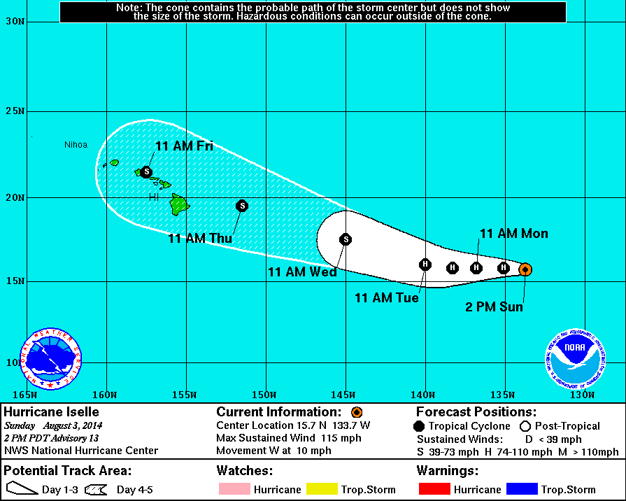
[Image: 0803stormCONE.jpg]
Reply
(09-05-2025, 01:37 AM)MyManao Wrote:
(09-05-2025, 12:59 AM)Durian Fiend Wrote: And BTW, the images above don't reflect Durgin's "narrative". 

I think you're confusing my use of the word 'narrative' with 'conclusions'

Those images support his discussion.. his narrative. His conclusions, as you point out, are otherwise.

But then, what would I really know? I avoid FB.
OK.  I've had the impression you don't particularly care for Durgin, hence my assumption that your usage suggested he was putting a biased spin on his interpretations. 
(09-05-2025, 01:48 AM)HereOnThePrimalEdge Wrote: I forget - - 
A hurricane passing north of us has less damaging winds than one passing south, right?  That’s why Iselle created so much damage in Puna with 70-75 mph winds?

Anyone care to fill in the details of hurricane circulation patterns?

Correct.  The east to west speed of travel for the storm will amplify its strongest wind gusts as they move counterclockwise.
Reply
"Anyone care to fill in the details of hurricane circulation patterns?"

A good simple graphic that explains wind speed versus circulation patterns. 


So, based upon all the current updated forecasts, models, graphs, FaceBook and PunaWeb armchair meteorologists, it appears that one could reasonably surmise that Tropical Storm/Hurricane Kiko will do one, or more, or even possibly all of the following:

1. Miss Hawaii Island by going to the south of the Island.
OR
2. Miss Hawaii Island by going to the north of the Island.
OR
3. Hit Hawaii Island directly.
OR
4. Fizzle out before it gets close to Hawaii Island.

We have come a long way.
“I could say the stupidest things and you’d clap” 
-DJT
Reply
(09-05-2025, 03:06 AM)HiloJulie Wrote: "Anyone care to fill in the details of hurricane circulation patterns?"

A good simple graphic that explains wind speed versus circulation patterns. 


So, based upon all the current updated forecasts, models, graphs, FaceBook and PunaWeb armchair meteorologists, it appears that one could reasonably surmise that Tropical Storm/Hurricane Kiko will do one, or more, or even possibly all of the following:

1. Miss Hawaii Island by going to the south of the Island.
OR
2. Miss Hawaii Island by going to the north of the Island.
OR
3. Hit Hawaii Island directly.
OR
4. Fizzle out before it gets close to Hawaii Island.

We have come a long way.

I believe we could have rejected 1 and 4 by last night already.  No update yet from Durgin.  Current track has Kiko as a powerful storm exiting stage North just in time to spare us serious winds. Also, it's possible we won't even get a good rain out of it.
Here's the NWS 5 AM update: "Kiko will remain over warm waters of 27–28C for the next 18 hours,
while influenced by light northeasterly vertical wind shear,
although the cyclone will remain in a drier than optimal mid-level
environment keeping the storm size smaller than average. Despite
the dry mid-level airmass Kiko will be moving through, the other
factors still appear favorable for some slight intensification, so
the latest intensity forecast still shows a little short-term
strengthening. This forecast also fits in with the possibility for
Kiko to develop annular characteristics which could keep it stronger
than the forecast intensity guidance. Thereafter, Kiko will move
over slightly cooler waters and an even drier mid-level environment.
These less favorable conditions should begin a gradual weakening
trend, in spite of the very light vertical wind shear. Waters below
26 C await Kiko's track after Monday, with west-southwesterly
vertical wind shear increasing steadily to more than 30 kt by
Wednesday, making it more likely the nearby dry air gets imported
into Kiko's small core. The increasingly hostile environment should
lead to rapid weakening of the tropical cyclone as it approaches
the Hawaiian Islands from the east-southeast. The official
intensity forecast has been lowered slightly from the previous
advisory cycle, but remains on the higher end of the intensity aids
through 48 hours. The intensity forecast then trends closer to the
middle of the intensity consensus envelope by Monday, and then
trends lower as Kiko should convectively sputter while moving very
close to the eastern end of the Hawaiian Island chain as a weakening
tropical storm.

Key Messages:

1. Kiko is forecast to approach the Hawaiian Islands during the
early to the middle portion of next week. Impacts from rain and wind
remain a possibility, but it is too soon to determine the exact
location or magnitude of these impacts, and interests there should
continue to monitor the progress of this storm."


FORECAST POSITIONS AND MAX WINDS

INIT 05/1500Z 14.2N 137.1W 100 KT 115 MPH
12H 06/0000Z 14.5N 138.5W 100 KT 115 MPH
24H 06/1200Z 15.0N 140.3W 105 KT 120 MPH
36H 07/0000Z 15.7N 142.2W 105 KT 120 MPH
48H 07/1200Z 16.4N 144.2W 100 KT 115 MPH
60H 08/0000Z 17.5N 146.2W 95 KT 110 MPH
72H 08/1200Z 18.5N 148.4W 80 KT 90 MPH
96H 09/1200Z 20.7N 152.8W 55 KT 65 MPH
120H 10/1200Z 22.6N 157.5W 35 KT 40 MPH
Reply
(09-05-2025, 12:59 AM)Durian Fiend Wrote:  Both images show a fairly well defined storm quite close to our island.  What else is there to describe?    

The units on the axes and the fact that the models produced by them are not based on real-world data. They are just pictures.
Reply
Here’s Durgins latest:

“Kiko is looking like an annular storm and as such is likely to survive the drier air to its northwest as it heads that in that direction. A stronger storm will turn more towards the upper level trough and farther away from us.

As Kiko approaches our latitude it is forecast to encounter southwesterly shear from the aforementioned upper level trough. The GFS keeps the storm intact, but weakens it significantly. The European model shows the storm possibly decoupling, with the upper level low heading mostly north and the low level circulation and moisture field heading towards us from the east. This scenario would bring widespread rain. But neither solution shows much wind for our island at this point. “
Reply
Thanks for the update Durian Fiend.  All good news.  

Borrowing from Ken Kesey who once said “you’re either on the bus or off the bus,” we’re either in the cone or out of the cone, and I’m quite pleased to be out of the cone.
Reply
But not too far out of the cone please. We desperately need the rain.
Certainty will be the death of us.
Reply
(09-06-2025, 01:36 AM)kalianna Wrote: But not too far out of the cone please.  We desperately need the rain.

OMG, do I agree.. try taking a trip through the makai side of Hamakua.. the cows are eating dried out grass stumps, and the ironwoods are dying.. it looks apocalyptic.. 

And still, the one post through this entire thread that really struck home was..

(09-05-2025, 02:30 AM)ironyak Wrote: As a "fun" reminder of the fallibility of predictive models, here is the NWS 5-day forecast for Iselle in 2014, which also shows the storm center passing to the north of us. Is that how it went, or did we get to spend days chainsawing out blocked roads and weeks without power after the storm hit lower Puna? (ETA:Those winds from the counter-clockwise rotation and path to the south were no bueno here or for Lahaina in 2023, diba?)

[Image: 0803stormCONE.jpg]

Which is to say.. as in that pic from Iselle there's still unknowns and possibilities and lets just see how this all unfolds.. and yes, hopefully we at least get some of that moisture come our way.
Reply
Well, it looks like all attempts to coerce that buggah into being a run for your life the big one is coming kine storm have fizzled out into well hopefully we'll get something, anything, even a few drops to feed our dried out turning to dust tropical rainforest.. and yet I can't resist noting that the NWS, in yesterday's 5pm discussion even threw the Maunas an honorable mention. Imagine that. I mean, after the years of being told (right here on PW) our terrain is insignificant, and still insisting that our mountains are hurricane killers, and severely effect the steering of any storm that waddles into our vicinity, it's pretty cool when they say..

As reported at BIVN here..

https://www.bigislandvideonews.com/2025/...ptember-5/

Where in part it reads..

The official forecast track is near the HCCA consensus and essentially unchanged from the previous advisory. However, a track slightly to the left of the official forecast would bring Kiko closer to the Big Island. Historically, cyclones approaching the Big Island from the east can slow and deflect northward as the island terrain disrupts the low-level flow and alters the steering currents.

Fun...
Reply


Forum Jump:


Users browsing this thread: 1 Guest(s)